
Wildfires are one of the most significant threats to ecosystems, human settlements, and public health. Every year, regions such as the western United States experience an increasingly severe wildfire season, with billions of dollars in damages, thousands of homes destroyed, and lives lost. Traditional empirical and statistical methods developed in past decades have provided some predictive capacity, but these approaches often fall short due to inadequate historical wildfire data, non-linear factor relationships, and the rapidly changing climate.
Today, AI powered wildfire prediction models are redefining how governments, scientists, and emergency responders predict wildfires, detect fire hotspots, and accurately predict wildfire spread. By combining historical wildfire data, satellite imagery, machine learning techniques, and AI algorithms, we now have the ability to reverse engineer wildfire behavior and make proactive decisions that can save lives and reduce destruction.
Introduction to Wildfire Prediction
For decades, wildfire prediction heavily relied on statistical methods such as regression models or empirical observations like fuel moisture levels and wind direction. While useful, these models often ignored the complex interactions between climate, vegetation, and human activities.
Challenges with Traditional Methods:
-
Dependence on limited historical data and small regional datasets.
-
Difficulty handling non-linear relationships (e.g., how wind, slope, and dryness together accelerate wildfires).
-
Low accuracy in predicting wildfires’ progression across different terrains.
This is where artificial intelligence makes a difference. By analyzing vast amounts of past wildfires data, coupled with high resolution satellite images, AI models can capture patterns that traditional methods simply cannot.
“Artificial intelligence allows us to see the invisible relationships in fire behavior that were hidden in traditional approaches.” – Computer Science Research, Early Study Proof Published in 2022
The Role of Artificial Intelligence in Wildfire Management
Artificial intelligence (AI) has transformed wildfire management into a data-driven science. By harnessing AI, emergency responders and governments can move from reactive fire suppression to proactive wildfire prevention.
Applications of AI in Wildfire Management:
-
Fire Risk Prediction – AI identifies high risk areas by analyzing vegetation density, humidity, and weather data.
-
Hotspot Detection – AI-powered detection systems recognize smoke plumes and fire hotspots using real-time satellite data.
-
Predicting Wildfire Spread – AI models simulate wildfire’s progression across terrain, improving resource allocation for firefighting.
-
Post-Fire Analysis – Reverse engineering wildfire behavior helps assess damage and strengthen future prevention strategies.
For example, in Santa Barbara County, AI systems trained on historical wildfire data from Lake Fire and multiple blazes in California provided early detection alerts, enabling emergency responders to evacuate residents hours earlier than traditional systems.
Wildfire Prediction Models and Applications
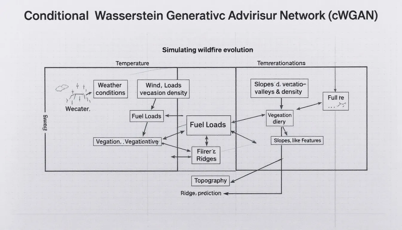
Among the many AI-powered models, Conditional Wasserstein Generative Adversarial Networks (cWGANs) stand out. These models simulate factors influencing wildfire evolution such as:
-
Weather conditions (temperature, wind, humidity)
-
Fuel loads (vegetation dryness, density)
-
Topography (slopes, valleys, ridges)
Case Example: Using Satellite Imagery + AI
-
Input Data: Historical fire incidents, past wildfires, and satellite imagery from NASA’s MODIS & Landsat programs.
-
AI Processing: Machine learning techniques analyze images to detect fire growth patterns.
-
Output: Accurate predictions of future fires’ spread.
Table: Traditional vs. AI-Powered Wildfire Prediction
|
Aspect |
Traditional Methods (Statistical) |
AI-Powered Methods (Machine Learning) |
|---|---|---|
|
Data Used |
Limited weather & fuel records |
Historical wildfire data + satellite images |
|
Prediction Accuracy |
Moderate, often regional |
High, scalable to global predictions |
|
Ability to Predict Spread |
Poor beyond initial fire detection |
Can model wildfire’s progression dynamically |
|
Adaptability |
Hard to adapt to changing conditions |
Continuously learns from new fire incidents |
|
Early Detection of Hotspots |
Limited |
Detects smoke plumes and hotspots in real-time |
Future of Disaster Preparedness and Response
The future of wildfire prediction lies in the integration of AI, satellite imagery, and machine learning techniques. As the western United States continues to experience increasingly severe wildfire seasons, investment in AI systems will be critical for wildfire management.
Benefits of AI-Powered Disaster Preparedness:
-
Early Detection Systems – Smoke plume recognition ensures early warnings.
-
Optimized Emergency Response – AI models guide fire departments on where to deploy resources first.
-
Better Evacuation Plans – Real-time predictions help minimize loss of life.
-
Global Scalability – AI prediction models are applicable not just in the US, but in Australia, Mediterranean regions, and India where forest fires are rising.
Key Future Research Areas:
-
Improving AI accuracy in fire prone areas with limited historical data.
-
Building cloud-based global wildfire prediction networks.
-
Integrating drones + AI for high resolution satellite images at local scales.
-
Training AI systems on climate change-adjusted data to predict future wildfires under extreme heat conditions.
“The next decade of wildfire management will belong to AI. Not only will we predict wildfires — we will prevent them.” – Disaster Preparedness Analyst, 2025
Useful Resources
-
US Forest Service – Fire Management Research
Also read related content on sustainable ecosystems and climate resilience on GoGreenInsights and the role of AI in emerging technologies at NextGenTech Info.
Final Words
AI powered wildfire prediction models are not just about predicting wildfires—they are about saving lives, ecosystems, and economies. By combining satellite imagery, machine learning, and historical wildfire data, these systems offer accurate predictions, optimize emergency response, and enable wildfire prevention in ways never before possible.
As wildfires evolve with climate change, AI gives us the ability to reverse engineer wildfire behavior and act before destruction occurs. The future of disaster preparedness is AI powered, data driven, and globally scalable—a path towards resilience against one of nature’s most destructive forces.
FAQs
Q1: How does AI improve wildfire prediction compared to traditional methods? AI can process large historical datasets and satellite images, finding hidden patterns and non-linear relationships that traditional methods miss.
Q2: Which regions benefit most from AI wildfire prediction models? Areas with frequent wildfires like California, western United States, Australia, and Mediterranean countries gain the most.
Q3: Can AI predict wildfires in areas with limited historical data? Yes, but accuracy improves as more real-time data and satellite imagery are integrated into the AI models.
Q4: What role do emergency responders play in AI-powered systems? AI provides early detection and spread predictions, but human decision-making is still crucial for evacuation, firefighting, and community safety.
Q5: What technologies are combined in AI wildfire models? They integrate machine learning, satellite imagery, computer science, and climate science to build prediction systems that continuously learn from past wildfires and new fire incidents.
